Geographical location of Andhra pradesh:-
Introduction:-
This is one of the south Indian states and is positioned in the coastal area towards the south eastern part of the country. Because of its location in the merging area of the Deccan plateau and the coastal plains, the state has got varied physical features. Being ruled by some of the famous dynasties in the historical times, this south Indian state is said to have a rich cultural heritage. Historically known as the “Rice Bowl of India”, this state has got a number of places of visit that are of historical importance. Andhra Pradesh occupies fifth position in terms of area. The state is sprawled in an area of approximately 2, 76, 754 sq kms. Location of this state lies between 77° and 84° 40` North latitude and 12° 41` and 22° East longitude. This state shares boundary with Orissa and Madhya Pradesh in north, in east with Bay of Bengal, Karnataka and Tamil Nadu to its south and in west, Maharashtra flanks the border. For smooth administration of this state, it has been divided into twenty three districts. There are three prominent regions as per geographical aspects, and these are Telangana, Kosta or Coastal Andhra and Rayalseema. To the west of Deccan Plateau Ghats, Telangana region lies. From Western Ghats, Godavari River and Krishna River originates and flow eastwards towards Telangana region and finally pours into Bay of Bengal. Amidst ranges of Eastern Ghats, Coastal Andhra occupies coastal plain region. This region runs along the length of Andhra Pradesh State and Bay of Bengal. On its south east, Rayalseema region is located close to the Deccan Plateau, and it lies within Pennar River Basin. The low lying Erramala hills, separates the state from Telangana region and Eastern Ghats separates it from Coastal Andhra.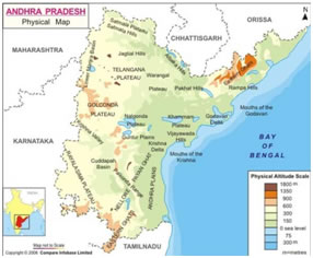
Area:
- At the time of formation – 160,205 km2
- Andhra Pradesh is the 8th largest state in the country in terms of geographical area with 162,760 sq km (after merging 7 mandals of Khammam District in AP)
- Coastal Andhra – 95.47 thousand sq.km
- Rayalaseema – 67.29 thousand sq.km
- Andhra Pradesh shares 4.96 % of Indian territory
- Largest district – Ananthpur 19,130 sq.km
- Smallest district – Srikakulam 5,837 sq.km
Seven mandals included in Andhra Pradesh:
- Kukkanur
- Velerupadu
- VR Puram
- Chinthanur
- Koonavaram
- Bhadrachalam (excluding Bhadrachalam temple)
- Burgampadu
Forests:-
- Area – 34,572 sq.km as per forest records
- 58% of total geographical area
According to Socio Economic Survey 2015-16:-
- Forest Area – 36914.78 Sq. Kms
- Very Dense Forest – 651.25 Sq. Kms
- Moderate Dense Forest Area – 11810.22 Sq. Kms
- Scrub Forest – 9241.77 Sq. Kms
- Non-Forest : 3900.49 Sq. Kms
Coastline:–
Andhra Pradesh also boasts of the second longest coastline in India, which stretches upto 970 km. The long coastline has been unofficially divided into three geographic regions, known by the names of Kosta, Telangana and Rayalaseema respectively. Andhra Pradesh possesses many hills that run intermittently, separating the state into western and eastern (coastal) Andhra. The hill ranges like Simhachalam, Annavaram, Srisailam and Tirumalai-Tirupati, have become the integral geographical part of state’s life and history. Godavari and Krishna are the two major rivers that pass through this state. The basins of these rivers and their tributaries cover almost 75% of the state territory. Apart from these major rivers, there are around 17 other rivers and streams flowing through Andhra Pradesh. The state also observes substantial topographical variations, due to thick forest in the north east, beaches next to the Bay of Bengal, plane paddy lands in the coastal plains and the barren boulder-spotted region near Hyderabad
Regions:-
The state includes the eastern part of Deccan plateau as well as a considerable part of the Eastern Ghats. The entire state is divided into the following 3 distinct regions:
- Telangana Region
- Rayalaseema Region
- Coastal Andhra Region
The northern side of the Deccan plateau is marked as the Telangana region, while the southern side is known as the Rayalaseema region. River Krishna separates these two regions from each other. The other rivers flowing through the state are Godavari and Penner. The coastal area of the state is mostly formed by the deltas of these rivers of Andhra Pradesh. Depending on their geographical location, the climate of the respective regions is featured with considerable variations. The summer season in this state, generally, stretches from the month of March to June. The coastal areas have got comparatively high temperature than the other parts of the state. The average temperature ranges from 20° C to 41° C. The summer is followed by the monsoon season, which starts during July and continues till September, when the heavy rainfall is received by the state from the south west monsoon. The north east monsoon contributes to around one third of the annual rainfall. This monsoon, usually, occurs during the months of October and November. Featured by tropical rains, this season plays a vital role in the identification of the nature of the state’s climatic conditions. The period in between November and February is said to be the winter season in Andhra Pradesh. The winter temperature is not too cold and ranges in between 12° C to 30° C.
Geology:-
Geologically ![]() the state consists of igneous,metamorphic & sedimentary formations. Peninsular Geneissic Complex consisting of Archaean Group covered by complex group of Gneisses and Schists. The Precambrian Sedimentary formation of the Cuddapah Super Group, Pakhal Super Group and Kumool Group are found in Kurnool, Cuddapah, Ananthapur, Chittoor, Nalgonda, Mahabubnagar, Guntur, Krishna and Khammam Districts. The Bhima’s are found in the western part of Rangareddy District, the Gondwana Super Group in Khammam, Warangal, Karimnagar and Adilabad Districts. The Deccan Traps are found in Rangareddy, Nizamabad, Medak and Adilabad Districts. Outcrops of Tertiary formations are found in East and West Godavari and Vishakapatnam Districts and the Quaternary sediments as thick blankets of alluvium are found in the river valleys, deltas and along the East Coast.
the state consists of igneous,metamorphic & sedimentary formations. Peninsular Geneissic Complex consisting of Archaean Group covered by complex group of Gneisses and Schists. The Precambrian Sedimentary formation of the Cuddapah Super Group, Pakhal Super Group and Kumool Group are found in Kurnool, Cuddapah, Ananthapur, Chittoor, Nalgonda, Mahabubnagar, Guntur, Krishna and Khammam Districts. The Bhima’s are found in the western part of Rangareddy District, the Gondwana Super Group in Khammam, Warangal, Karimnagar and Adilabad Districts. The Deccan Traps are found in Rangareddy, Nizamabad, Medak and Adilabad Districts. Outcrops of Tertiary formations are found in East and West Godavari and Vishakapatnam Districts and the Quaternary sediments as thick blankets of alluvium are found in the river valleys, deltas and along the East Coast.
The State of Andhra Pradesh abounds in a variety of mineral deposits with about 48 minerals, some of which are unique in nature like that of Barytes, Chrysotile Asbestos and Green Quartz. Most of the mineral deposits are related to the nature and composition of the country rocks in which they occur and also the geological structure.The Dharwar Schists and the associated Gnesisses and Granite contain a large variety of metallic ores such as Gold, Manganese, Chromite, Copper, Iron Ore, Bauxite and Wolframite. Deposits of non-metallic minerals like Diamond, Apatite, Corundum,Feldspar, Garnet, Quartz, Green Quartz, Amethyst, Graphite, Kyanite and Mica are also found in them. These Archaean Group
of rocks is a storehouse for different varieties of Gneisses, Charnockites, Granites, Anorthosites, Dolerite Gabbro, Khondalites, Quartzites,Granulites, Migmatites, Lyptenites, Syenites and Crystalline Limestone which are useful in building, cutting and polishing industry. The Copper and Lead ores. Barytes, Clays, Red-ochres, Asbestos, Haematite,Steatite and Diamond are the important mineral deposits found within the Cuddapah,Kurnool and Pakhal Groups. Some of the rocks within this group, particularly the Quartzites, Limestone, Marble, Dolomite, Slates and Sand Stones are good building stone and are found in significant quantities. The Gondwana group contains vast deposits of Coal and Refractory Clays like Fire Clay and Ball Clay. The Pleistocene formations occurring both on-shore and off-shore contain oil and natural gas. The recent formations comprising of Alluvium. Sand and Soils yield good Brick Clays and Sand for building and other purpose. The coastal heavy sands contain rich llmenite, Rutile, Monazite, Zircon, Gamet and other minerals. Andhra Pradesh is gifted with a vast and varied decorative/dimensional stones viz, Granites, Limestone Slabs, Marble, Slate, Phyllite, Quartzite etc. Globally known for exclusive and unique Chimakurthy Black Galaxy Granite and other varieties like Warangal Jet Black, Khammam Black, Srikakulam Blue and White, Karimnagar Tan Brown, Ananthapur Chilly Red. Chittor Kuppam Green etc. The Granite varieties of Andhra Pradesh confim to the highest international standards and provide excellent uniformity, consistency and have been used in several well known buildings all over the world. Various colours of Limestone Slabs from Tandur, (Rangareddy District),Betamcharla (Kurnool District), Tadipatri (Ananthapur District), Macherla (Guntur District), Mudimanikyam (Nalgonda District) are well known for flooring and paneling purposes within the country and are also being exported to many countries. Slate and Phyllites in various shades of colours from Prakasam, Guntur and Nalgonda Districts are used as decorative stones and are being exported to various countries.
Disaster Risk Profile
Andhra Pradesh is exposed to cyclones, storm surges, floods and droughts. A moderate to severe intensity cyclone can be expected to make landfall every two to three years. About 44 percent of the state is vulnerable to tropical storms and related hazards. In India, the cyclones develop in the pre-monsoon (April to May) and post-monsoon seasons (October to December), but most of them tend to form in the month of November. Cyclones on the east coast originate in the Bay of Bengal, the Andaman Sea or the South China Sea, and usually reach the coastline of Tamil Nadu, Andhra Pradesh, Odisha and West Bengal, which are the most vulnerable to these types of hazards. Two of the deadliest cyclones of this century, with fatalities of about 10,000 people in each case, took place in Odisha and Andhra Pradesh during October 1971 and November 1977 respectively. The super cyclone of Odisha in 1999 caused large scale damage to life and property. Along the Andhra coast, the section between Nizampatnam and Machilipatnam is the most prone to storm surges. Vulnerability to storm surges is not uniform along Indian coasts. The following segments of the east coast of India are most vulnerable to high surges
- North Odisha, and West Bengal coasts.
- Andhra Pradesh coast between Ongole and Machilipatnam.
- Tamil Nadu coast, south of Nagapatnam.
The states bordering the Arabian Sea on the west coast are not completely safe either, as Kerala, Gujarat -and to a lesser extent Maharashtra -are also prone to cyclones. With a frequency of four cyclones per year, one of which usually becomes severe, the Bay of Bengal accounts for seven percent of the annual tropical cyclone activity worldwide. Despite this relatively low percentage, the level of human and property loss that cyclones cause around the Bay is very high. Once the cyclones enter the mainland, they give way to heavy rains which often translate into floods, as it was the case with the damaging cyclone-induced floods in the Godavari delta, in August of 1986. Many drought prone areas adjacent to coastal districts in eastern maritime states are thus vulnerable to flash floods originated by the torrential rains induced by the cyclonic depression. In addition to cyclones and its related hazards, monsoon depressions over the north and central areas of the Bay of Bengal move until reaching north and central India, including portions of Andhra Pradesh, bringing heavy to very heavy rains and causing floods in the inland rivers between June and September. In Andhra traditionally, the flood problem had been confined to the flooding of smaller rivers. But the drainage problem in the coastal delta zones has worsened, multiplying the destructive potential of cyclones and increasing flood hazards. A critical factor is maintenance of irrigation systems. On several occasions, deaths have been caused by breaches in tanks and canals as well as over-flooding caused by silting and growth of weeds.
- APPSC GROUP 1 Mains Tests and Notes Program
- APPSC GROUP 1 Prelims Exam - Test Series and Notes Program
- APPSC GROUP 1 Prelims and Mains Tests Series and Notes Program
- APPSC GROUP 1 Detailed Complete Prelims Notes